Population Density

Population density = the average number of people living in each square kilometre.

This has been calculated using population data for each sub-ward (obtained from the Dar es Salaam municipalities), and then dividing the population of each sub-ward by the area (km2). The categories of LOW DENSITY, MEDIUM DENSITY and HIGH DENSITY are classified using tertile distribution, where each of the three groups contain one third of the total population of Dar es Salaam.

Population density is useful for determining the level of demand for solutions.

High Density - over 15,750 people per km2
Medium Density - 5,950 - 15,749 people per km2
Low Density - Below 5,949 people per km2

Access to Roads

Accessibility = Distance from vehicular access roads (+/- 50m)

The distance of 50 metres has been selected as the reasonable distance to provide sanitation services to areas NOT-SERVED by centralised infrastructure, by using a truck (E.g. FSM pit-latrine emptying via vacuum truck, solid waste collection via truck, water supply via tanker).

Road access is a useful for shortlisting options based on solution logistics.

NOTE: The area boundary of this category has been restricted to include only “urban” areas of Dar es Salaam, as “peri-urban” areas have different accessibility challenges.

The boundary of urban areas has been taken from the “Tanzania: Urban Extents” Map (source map can be found in our downloads section), which illustrate the shape and area of urbanised spaces. Urbanised localities are defined as places with 5,000 or more inhabitants that are delineated by stable night-time lights. For poorly lit areas, alternate sources are used to estimate the extent of cities.

The road network has been downloaded from the Open Street Map Project via the Geofabrik server. This data may be incomplete and only represents the roads which have been mapped by the Open Street Map community. The “paths and walk ways” have been removed from the larger road file before analysis.

Additional Local Data

In addition to the selected characteristics of Density, Accessibility and Income – context-specific local data is essential for selecting the most suitable solutions for specific areas, E.g. Flood prone or high ground water areas will require certain solutions.

Overlaying additional local data will also help identify areas requiring immediate intervention.

The layers showing cholera, flood prone and high ground water areas have been provided by SanMap.org. More details of the data collection methodology can be found at their website.

The Water Supply Network, Sewer Network and Waste Water Treatment Pond locations are provided by DAWASA.

Income Level

Household income is useful for shortlisting options based on solution affordability or users’ ability to pay for services.

As household income levels in Dar es Salaam are so varied – and accurate income data is difficult to obtain – it was not possible to overlay this category onto the map. Assumptions at such a large scale are not helpful, because when we take a closer look at each ward, it is common to find a range of different income levels at sub-ward and even at household level. Additionally, socio-economic conditions throughout the city are constantly changing, at a pace too fast to keep up with.

Therefore you are required to self-select the most realistic income category for your area of interest (low-income, medium-income and high-income).

Community water schemes established by DAWASA

Water Tanks

Bore Holes

Water Points

Service Area

Survey completed May 2015 for further information please contact DAWASA

What is CSP? Close

This city sanitation planning (CSP) website was created in response to the need for a simple, fast and flexible tool for determining “which sanitation solutions go where”. This tool uses selected demographic, physical and economic characteristics to determine the most suitable interventions for various areas around the city.
The following characteristics have been selected as the most relevant factors influencing environmental sanitation conditions within urban areas:

Population density + Accessibility (to roads) + Income
+ Additional local data
= Sanitation solutions

CSP has the following advantages:

CSP has been designed to assist decision-makers and practitioners involved in urban environmental sanitation planning in Dar es Salaam, such as:

How to use this tool?

On the left side of this page, you will find the option to overlay certain filters onto the map (E.g. population density, accessibility). Click these layers on and off, to gain an understanding about different conditions throughout the city.

On the right side of this page, you will see an option for “Environmental Sanitation Solutions”. After clicking on a particular area of the map, you will be shown the population density category + the accessibility category. You will then be guided to select the income level of your area of interest. Once all three parameters have been input, you will have the option to DOWNLOAD possible solutions for that exact area.
You can use the navigation bar at the top to zoom into a particular ward.

What is environmental sanitation?

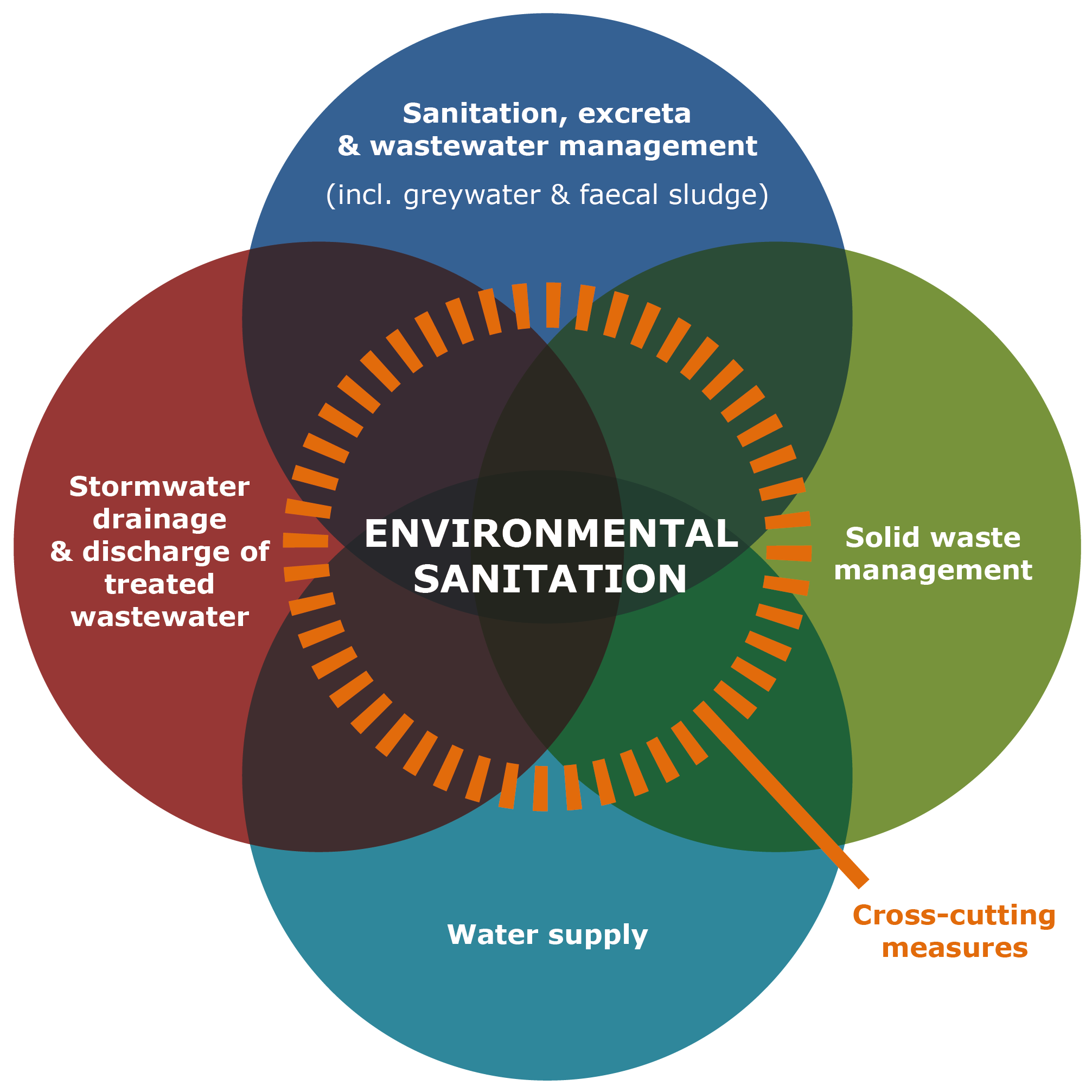
Environmental sanitation goes one step further than the traditional notion of “sanitation” which is limited to the immediate aspects surrounding human excreta and/or the provision of toilets. A holistic approach to achieving a sanitary urban environment considers all aspects related to hygiene, notably those aspects directly linked to human health and quality of life:

Contributors Close

DAWASA
Mwananyamala Hospital Road,
Opposite Mwananyamala Hospital
Dar es Salaam
Tanzania
E: dawasaceo@dawasa.co.tz
Tel: +255 22 2760006/15
Fax: +255 22 2762480


Creators

CSP methodology and content produced by:

Bremen Overseas Research and Development Association (BORDA) – Tanzania
Andreas Schmidt
Laura Bright-Davies
Faraja Mbuduka
Larissa Duma

Website programming by:
John Taylor

Maps By:

usabledata
David Taylor
david@usabledata.co

Project partners

This guide for city sanitation planning in Dar es Salaam is one component of a EU co-funded project entitled “Water Utility Partnership for Sustainable Service Delivery in Dar es Salaam”. This North-South partnership for capacity development in between the following project partners:

European Union
BMZ
Hamburg Wasser
CONSULAQUA Hamburg (CAH)
City of Hamburg
Dar es Salaam Water and Sewerage Authority (DAWASA)
Dar es Salaam Water and Sewerage Corporation (DAWASCO)
Dar es Salaam City Council
The Ministry of Water (MoW)
Downloads Close

This online planning guide is a more interactive, user-friendly adaptation of the 3-part City Sanitation Planning package, which can be downloaded in full here:

PART 1: Urban environmental sanitation – Integrating decentralised solutions
DOWNLOAD PDF
PART 2: 5 step planning guide – Which solutions go where?
DOWNLOAD PDF
PART 3: Catalogue of environmental sanitation solutions – For urban areas
DOWNLOAD PDF

For additional information on any of the environmental sanitation options mentioned within this planning guide, along with other city sanitation planning approaches, please refer to the following resources:

“Decentralised Wastewater Treatment Systems (DEWATS) and Sanitation in Developing Countries: A Practical Guide” – BORDA, 2009
DOWNLOAD PDF (Preview only - full version not available for download)
ORDER BOOK ONLINE
“Catalogue of Low-cost Toilet Options: for Dar es Salaam” – WEDC, 2004
ORDER BOOK ONLINE
“Compendium of Sanitation Systems and Technologies” 2nd Edition – EAWAG/SANDEC, 2014 DOWNLOAD PDF
“Faecal Sludge Management Book” – EAWAG/SANDEC, 2014 DOWNLOAD PDF
“Constructed Wetlands Manual” – UN-HABITAT, 2008
DOWNLOAD PDF
“Anaerobic Digestion of Biowaste in Developing Countries: Practical Information and Case Studies” - EAWAG/SANDEC, 2014
DOWNLOAD PDF
“Bidhaa za usafi wa mazingira kwa bei nafuu: CHOO BORA na MAZINGIRA SAFI. Wlaya ya Chamwino” – People’s Development Forum (PDF) & Polytechnic University of Madrid, 2013
DOWNLOAD PDF
Tanzania Urban Extents Map Source Data

Population density

[?]

Low Density

Medium Density

High Density

Access to Roads

[?]

No/Limited Road Access

Additional Local Data

[?]

Cholera Prone

Flood Prone

Cholera & Flood Prone

High Ground Water

Water Supply Network

Sewer Network

Wastewater Treatment Ponds

Community Water Schemes

[?]

Select All

Water Tanks

Bore Holes

Water Points

Service Area

What is CSP? v
Contributors v
Downloads v
Contact Us v

Navigate to your area of interest

Click on the map to learn more about a specific location